Welcome Home
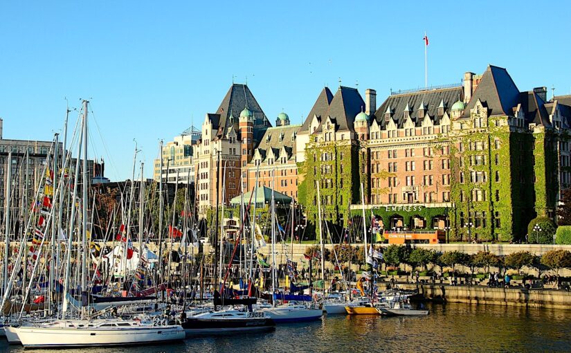
Vancouver Island, located in British Columbia, Canada, is the largest Pacific island east of New Zealand. Originally called Quadra and Vancouver Island after Spanish navigator Juan de la Bodega y Quadra and British navy officer George Vancouver, the island was first explored by British and Spanish expeditions in the late 18th century. The former’s name was eventually dropped and has since been known solely as Vancouver Island. It is one of several North American locations named after this British Royal Navy officer who explored the Pacific Northwest coast of North America between 1791 and 1794. While the city of Vancouver is located on the North American mainland, Victoria, the capital of British Columbia, is located on the island. Along with the minor islands near its southern portion, it is the only part of British Columbia that is south of the 49th Parallel.
The island is 460 kilometres (290 mi) in length, 80 kilometres (50 mi) in width at its widest point, and 32,134 km2 (12,407 sq mi) in area. It is the largest island on the western side of North America, the world’s 43rd largest island, Canada’s 11th largest island, and Canada’s second most populous island after the Island of Montreal. The Canada 2011 Census population is 759,366. Nearly half of these (344,630) live in Greater Victoria. Other notable cities and towns on Vancouver Island include Nanaimo, Port Alberni, Parksville, Courtenay, and Campbell River.
Economic Profile
Technology
Within the island’s largest city, Victoria, there is a significant IT and technology industry. According to the Victoria Advanced Technology Council website, over 800 technology companies operate in the Victoria area, with combined annual revenues of $1.95 billion. High Speed Internet is delivered to the island by Shaw Communications, Telus, and various local providers with their own networks. Wireless Internet connections can be found all over the Island, many free for public use. While the Island does generate much of its own power at several hydroelectric stations, increased demand required the construction of several high voltage power cables, both HVDC and AC, connecting to the Canadian Mainland.
Logging
Outside of Victoria, Vancouver Island’s economy is largely dominated by the forestry industry. Many of the logging operations are for export, although, historically, were for sawn lumber and pulp and paper operations. Recently, rotations are much shorter than the historical 80 years. Logging operations involving old-growth forests such as those found in Clayoquot Sound are controversial and have gained international attention through the efforts of activists and environmental organizations. Another source of controversy all over the Island are logging operations occurring in community watersheds. This is happening for two primary reasons: old-growth forests are nearly all cut, and communities have little recourse to protect their watersheds because the province of BC has no legislation giving communities the right to protect their watersheds.
Fishing
Fishing plays a large role in the lives of many islanders. Commercial fishing vessels operate out of the island’s ports and harbours, and coastal fish farms (controversially) produce many tons of Atlantic salmon yearly.
Tourism
In recent years the government of British Columbia has engaged in an advertising program to draw more tourists to beach resorts in places such as Tofino and Ucluelet. Sport fishing, whale-watching, hiking, SCUBA diving, and skiing are just a few things for which tourists visit Vancouver Island. Visitors also come to see Victoria’s nineteenth-century architecture, and the many villages which line the coast such as Cowichan Bay, Chemainus, and Qualicum Beach.
Education
Vancouver Island is home to a handful of universities, several trade-schools and colleges, hundreds of public schools, and a few dozen private schools (including Montessori and Waldorf schools).
Universities
- University of Victoria
- Vancouver Island University (formerly Malaspina University-College)
- Royal Roads University
Colleges
Public school districts
There are 11 school districts on Vancouver Island with several elementary, junior high, and high schools in each. Three school districts are in the Greater Victoria area and the other eight cover the rest of the island to the north. All public schooling falls under the jurisdiction of the British Columbia Ministry of Education.
Private schools
- St. Michael’s University School, Victoria, with campuses in Oak Bay and Saanich
- Glenlyon Norfolk, Victoria
- St. Margaret’s School, Victoria (limited to female students)
- Brentwood College, Mill Bay
- Shawnigan Lake
- Queen Margaret’s School, Duncan
- Dwight International School, Shawnigan Lake
- Sunrise Waldorf School, Duncan
- Island Oak High School, Duncan
- Maria Montessori Academy, Victoria British Columbia, located in Gordan Head
- Selkirk Montessori School, Victoria British Columbia, located at the Selkirk Waterway
- Lester B. Pearson College of the Pacific, Metchosin
- St. Joseph’s Chemainus Catholic Elementary School, Chemainus
- Duncan Christian School, Duncan
- Nanaimo Christian School, Nanaimo
- Pacific Christian School, Victoria
- Aspengrove School, Nanaimo
Transport
Sea
Marine transport is very important to Vancouver Island for access to the mainland of British Columbia and Washington. There are no bridges connecting the island to the mainland, although the idea of building one has been brought up many times. Major technical issues and cost are the largest barriers to a bridge currently though exact public support for the idea is not currently known. The only vehicle access to Vancouver Island is via ferries operated by BC Ferries, Washington State Ferries and Black Ball Transport Inc. There are seven vehicle ferry routes:
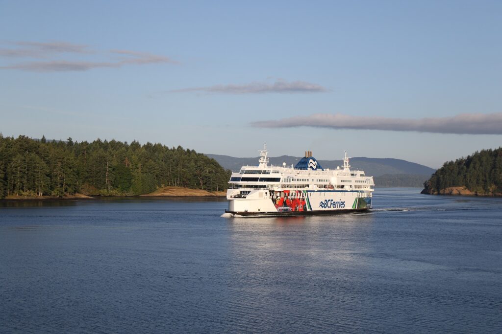
- BC Ferries
- Tsawwassen (38 km (24 mi) south of Vancouver) – Swartz Bay (32 km (20 mi) north of Victoria). Crossing time: 1 hour 35 minutes; 8 sailings per day in the fall, winter, and spring and more in summer)
- Tsawwassen – Duke Point (13 km (8 mi) south of Nanaimo). Crossing time: 2 hours; 8 round trips daily.
- Horseshoe Bay (19 km (12 mi) northwest of Vancouver) – Departure Bay (3 km (2 mi) north of downtown Nanaimo). Crossing time: 1 hour 35 minutes; Sailings every 2 hours with extra sailings during the summer and holidays.
- Gulf Islands – Swartz Bay. Crossing time: 35 minutes- 3 hours depending on island of departure; 4 or more trips daily.
- Powell River – Comox. Crossing time: 1 hour 20 minutes; 4 round trips daily.
- Port Hardy – Prince Rupert. Service daily or on alternate days; changes seasonally.
- Washington State Ferries
- Anacortes, Washington – Sidney. Crossing time: 2 hours (not counting stops in the San Juan Islands)
- Black Ball Transport
- Port Angeles, Washington – Victoria. Crossing time: 1 hour 30 minutes; 1 to 4 round trips daily; changes seasonally.
- Passenger-only service
In addition, there is passenger-only ferry services from the mainland to Vancouver Island:
- Victoria Clipper (Seattle, Washington – Victoria). Crossing time: 2 hour 45 minutes; 1 to 3 round trips daily
Rail
There are two remaining major railways on Vancouver Island. The Southern Railway of Vancouver Island, which assumed control of the Esquimalt and Nanaimo Railway from RailAmerica in July 2006 offers general freight service on the Victoria–Courtenay main line (called the Victoria Subdivision by the railroad). The Port Alberni branch line (called the Port Alberni Subdivision by the railroad) has been out of service since late 2001.
SVI also runs passenger service under contract with Via Rail. Western Forest Products operates the Englewood Railway which is Canada’s last logging railway, running from Woss to Beaver Cove on the northern end of the island. The former Canadian National Railway out of Victoria to the Cowichan Valley was abandoned in the late 1980s/early 1990s, and the former grade between Victoria and Sooke is now the multi-use Galloping Goose Regional Trail. The BC Forest Discovery Centre has a narrow gauge railway winding around the park, and the Alberni Pacific Railway operates during the summer from the restored E&N Railway station in Port Alberni to the McLean’s Mill on former E&N Railway trackage.
Road
There is one major north-south highway system on the island, which runs along the eastern side. It begins in Victoria as Highway 1 which is part of the Trans-Canada highway system as far as Nanaimo. There, Highway 19 takes over and continues to Port Hardy. The route is a patchwork of two-, four-, and six-lane roadways between Victoria and Port Hardy. The engineering characteristics and traffic control systems of the roadway vary widely from one city or district to the next and include the following variations:
Trans-Canada Highway:
- Congested, heavily signalized four-lane urban core streets with heavy pedestrian activity in Victoria and Duncan.
- Short four- to six-lane freeways with interchanges just west of Victoria and just south of Nanaimo.
- A paved but treacherous two-lane to three-lane winding mountain arterial road through the Malahat pass that is subject to frequent accidents and closures.
- A moderate to heavily signalized four-lane divided arterial road from Mill Bay to Nanaimo (interrupted by the Duncan urban-core bottleneck).
Highway 19:
- A moderate to heavily signalized bypass called the Nanaimo Parkway.
- A lightly signalized four-lane divided arterial road from the Parkway to Parksville.
- A stretch of four-lane high-speed freeway from Parksville to Comox.
- A moderate-speed two-lane arterial highway north to Campbell River and Port Hardy.
Without a “fixed link” to the BC mainland, there is little probability of substantial improvements in the mobility characteristics of some of the more congested or heavily signalized sections of the Island Trans-Canada Highway or the Nanaimo Parkway. Proposals have been made for this kind of link for over a century. Because of the extreme depth and soft seabed of the Georgia Strait, and the potential for seismic activity, a bridge or tunnel would face monumental engineering, safety, and environmental challenges at a prohibitive cost.
Another major north-south route is Highway 17 a four-lane divided highway that has a mix of interchanges and traffic lights. It connects Victoria with the Saanich Peninsula, terminating the Vancouver Island portion of its route at the Swartz Bay Ferry Terminal.
The main east-west routes are mostly two-lane but are generally free of the congestion seen on some of the four-lane highways. They comprise the following:
- Highway 4 between Qualicum Beach and Tofino;
- Highway 14 between Greater Victoria and Port Renfrew;
- Highway 18 between Duncan and Lake Cowichan;
- Highway 28 between Campbell River and Gold River; and
- Highway 30 between Port McNeill and Port Alice.
Vancouver Island is also well served by secondary routes, a growing number of which have efficient roundabouts in place of the traffic lights that can back up traffic on the main highway routes. Numerous active and decommissioned logging and forest service roads provide access into the back country.
Many communities are served by public transit. Greater Victoria is one of the few places in North America where double-decker buses are used in the regular public transit system.
Air
- Victoria Airport is the major airport on Vancouver Island. In 2010, it was the 9th busiest airport in Canada in terms of passenger movements (1,464,420). Six major carriers (Air Canada, Air Canada Jazz, United Airlines, Horizon Air, Pacific Coastal Airlines, WestJet and WestJet Encore) offer a variety of direct flights of short and medium distance including to and from Seattle, San Francisco, Calgary, Edmonton, Vancouver, and Toronto. Victoria International also has seasonal service to Puerto Vallarta, Cancun, Las Vegas, and Honolulu.
- CFB Comox (YQQ)
- CFB Comox/Comox Valley Airport is a shared military and civilian airport. In 2010 the Comox Valley Airport was the second busiest airport on Vancouver Island in terms of passenger movements (291,910).It offers direct flights to Calgary, Edmonton, Vancouver, and Campbell River several times daily, as well as Puerto Vallarta, Mexico, on a weekly basis through WestJet.
- Nanaimo Airport (YCD)
- Nanaimo Airport has flights with Air Canada Jazz to Vancouver and Island Express Air to Victoria and Abbotsford. A recently installed (as of February 2010) instrument landing system and runway extension has improved the capacity, safety, and punctuality of flights. There are more improvements slated for completion March 2011.
- Qualicum Beach Airport (XQU), Tofino Airport (YAZ), Campbell River Airport (YBL) and Port Hardy Airport (YZT)
- Qualicum Beach, Tofino, Campbell River and Port Hardy have small airports capable of handling private aircraft and small commercial jets.
- Harbour Airports and Heliports
- Floatplane and helicopter traffic to and from Victoria’s Inner Harbour (YWH) accounted for 261,712 passengers in 2010, making it the third busiest airport on Vancouver Island. Nanaimo Harbour (ZNA) also operates a busy water aerodrome. Much of the floatplane traffic is downtown-to-downtown service between these two and Vancouver Harbour, the primary carriers being Harbour Air, West Coast Air, and Baxter Aviation. Harbour Air also flies to other areas around Vancouver, service to Seattle’s Lake Union is provided by Kenmore Air, and Orca Airways runs flights between Vancouver and Tofino Harbour. These carriers make several daily scheduled flights, weather permitting. Helicopter service is provided by Helijet in Victoria and various private operators elsewhere.